POTENTIAL SNOW AMOUNTS
Late in the season these things get “fun” to try and figure out because there are so many variables. Know this – the lower elevation you are, but you get snow, the more likely it is that more falls than what you’ll measure. Higher snow rates will pile up, then when it lightens up there will be melting from below and compacting of the wet spring snow. Roads may slush up, then melt and be wet.
The varying rates of precipitation I described above in some cases could be due to convection – it’s the process that produces thunderstorms. We’ll have some around today and tonight, but then be a little less likely to have embedded thunder Thursday night, although I can’t rule it out. Thundersnow can do wild things for people underneath it!
In general, here are my rain/snow line thoughts…overnight Wednesday into Thursday morning it should get down to about 7,200’…rise to about 8,200′ Thursday, then come down to 6,000′ early Friday morning. The ebb and flow of that rain/snow elevation makes it tough to figure!
From an impact perspective, if you get snow and you’re lower than 7,200′ roads should stay wet. Between 7,200′-8,000′ roads may occasionally slush up, especially Thursday night, and snowpack is more likely above 8,000′
I hope this helps you plan!
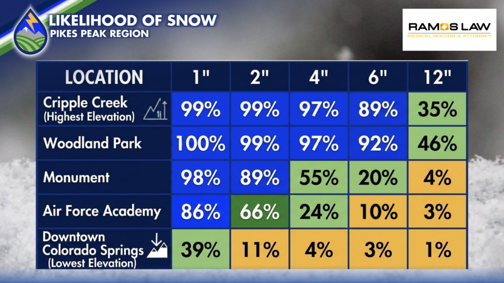
PROBABILITY IN FORECASTING
Here’s another way to look at the snow potential given the challenges that exist within the temperature structure of a late season storm. The blues indicate s higher probability (above 80%) that a certain amount of snow will happen and the yellows are less than 15% chance that a particular amount will happen at a given location.
I hope this helps paint a little bit different picture for you about the importance of elevation in these types of storms.