







Do you think we throw darts sometimes? Don’t lie. I know you do.
I’m showing you the forecasted liquid this week from two computer models because at the minimum it might make you think of a dart board since they starkly different.
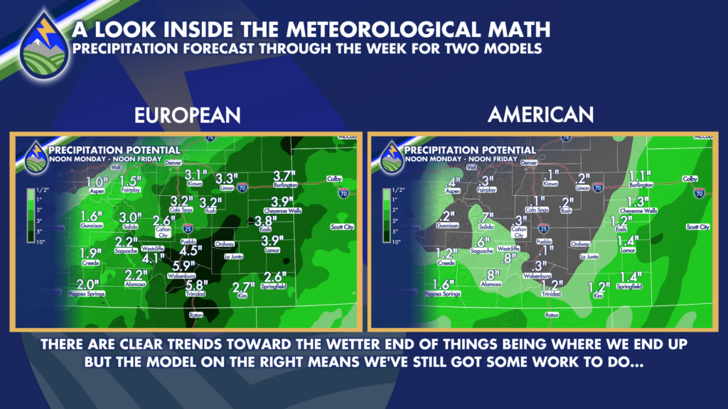
That said, there is important information here. Most models are trending and looking something like the European forecast on the left. When trends and concensus are heading in a certain direction, it’s hard to ignore and forecasts tend to trend that way.
However, the American (GFS) model on the right should at least be a signal that there is more work to still be done on the forecast.
Why are they so different? The American model is faster and not as strong with the approaching storm coming in off of California. It affects where and how the remnants of Hurricane Polo go and how much of it can get wrapped into the storm as it kicks out of the Great Basin into the plains.
The transition begins Monday as moisture starts arriving from the southwest. The San Juan Mountains and southwest Colorado will be first in line for more organized rain, and a Flood Watch is in effect there from Monday morning into the middle of the week. Flood watches are also posted in portions of Arizona and New Mexico as this broader weather pattern takes shape.
THE IMPORTANT TIMEFRAME
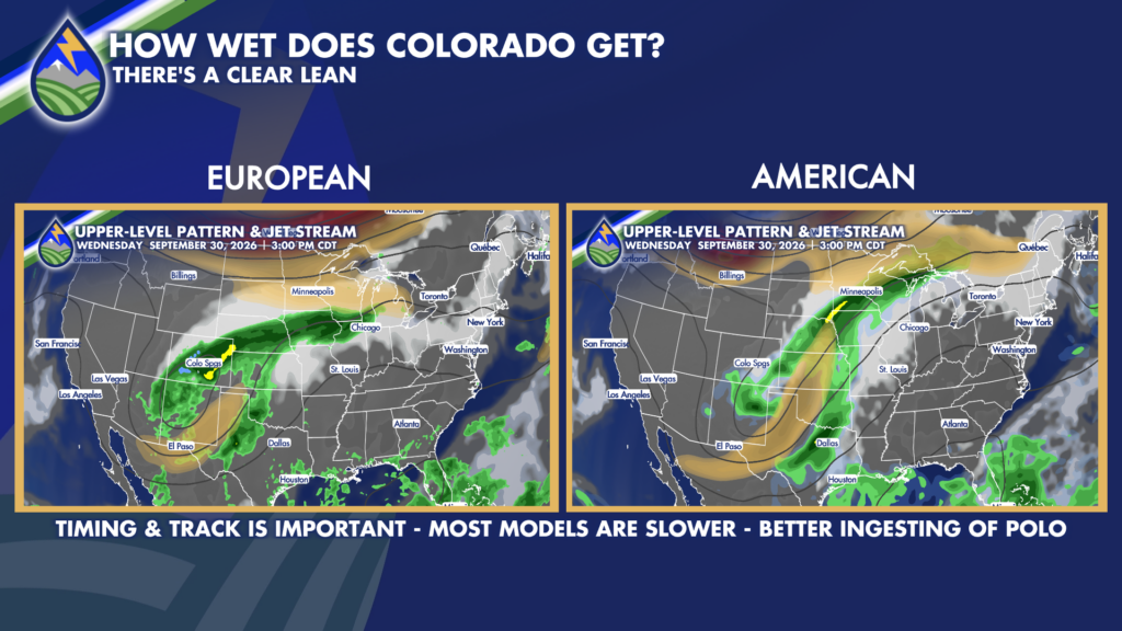
Tuesday may still keep the heaviest and most widespread rain farther south and west of much of the area, depending on the storm’s position. Areas closer to the Four Corners region, southwest Colorado, and the New Mexico border may see the wetter conditions earlier. For much of the I-25 corridor and the southeast plains, the better opportunity for widespread rain appears to center on Wednesday and possibly Thursday.
Wednesday currently looks like the leading candidate for the wettest day for many southern Colorado communities. If the slower, wetter version of this setup develops, rain could become widespread as the circulation approaches Colorado and winds aloft turn more favorable for bringing moisture into the region. The eventual track of the low near the Colorado-New Mexico line will matter a great deal. A track farther north or farther south could shift where the heaviest rain sets up and how long it lasts.
There is a real signal for heavy rainfall, but it is too early to lock in exact totals or pinpoint the highest-impact areas. Some forecast guidance shows the potential for very significant rainfall, including localized totals above five inches. That is not a guaranteed outcome, and another model is faster with the western storm, which would push more tropical moisture south and east while still bringing beneficial rain to southern Colorado. The difference between those scenarios is substantial, which is why the forecast will continue to evolve.
Even with those uncertainties, the overall message is becoming clearer: prepare for a cool and potentially wet middle of the week. Widespread rainfall totals in the 1-to-3-inch range are possible in favored areas, with locally higher amounts if the slower, wetter solution verifies. The greatest concern for heavier, longer-lasting rain may eventually focus along the eastern mountains, Raton Mesa, areas south of Highway 50, and parts of the southeast plains. Locations that normally do not receive several inches of rain in a short period could see flooding concerns develop quickly.
If widespread rainfall of two to five inches or more develops, flooding issues would be possible. Watch low-lying areas, normally dry washes, small streams, burn scars, poor-drainage roads, and places where water collects during heavier downpours. It is a good time to make sure drains are clear, know an alternate route if your usual road floods, and stay weather-aware if you live near a creek, arroyo, or burn scar. Never drive through water covering a roadway, especially at night when depth and road damage can be difficult to see.
BE READY FOR THE CHANGE – GET THE APP
Download the Peaks2PlainsWeather app so you’re ready for the week of high impact weather. It’s free to you because of partner support, here’s a convenient link:
https://onelink.to/peaks2plainsweather






