







Tropical Storm Simon is south of the Mexican Plateau, while Tropical Storm Rachel is well west of the Baja Peninsula. Rachel had been a hurricane earlier Thursday morning but has weakened to tropical-storm strength as drier air wraps into its circulation. That dry air is helping weaken the system, though Rachel’s remaining moisture could still become important for the Intermountain West.
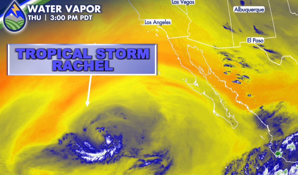
Over the next couple of days, Rachel is expected to curve north and east toward the northern Baja region. An incoming trough from the north may pick up moisture from Rachel and steer it into parts of Utah and western Colorado. The first signs of that moisture could arrive late Sunday and continue into Monday, with additional afternoon thunderstorms possible across the western slope and high country into Tuesday and Wednesday.
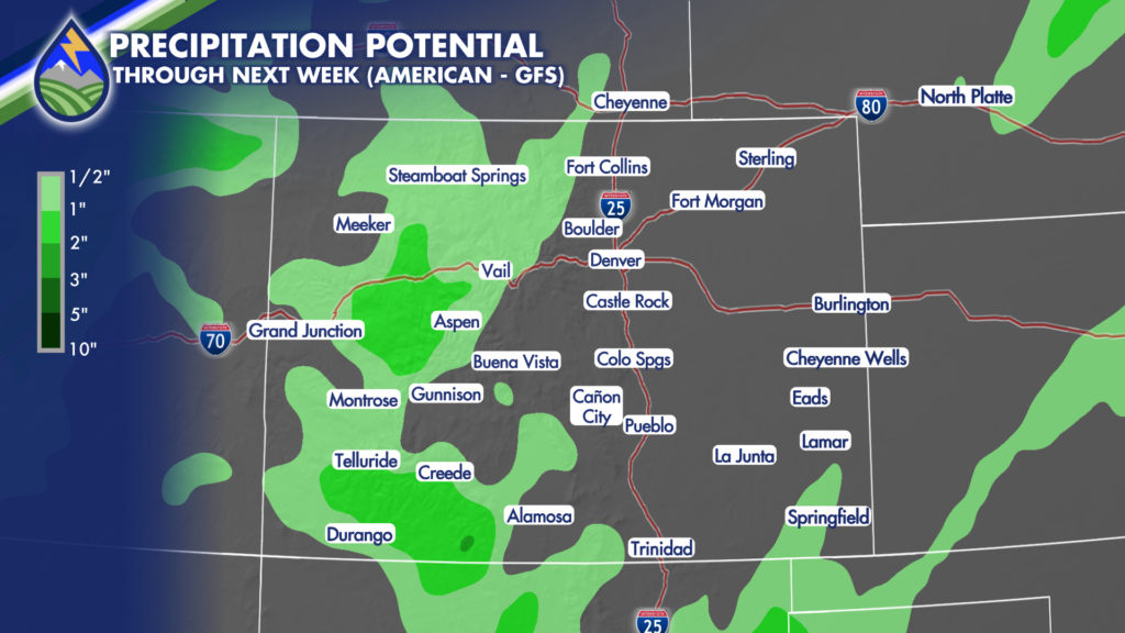
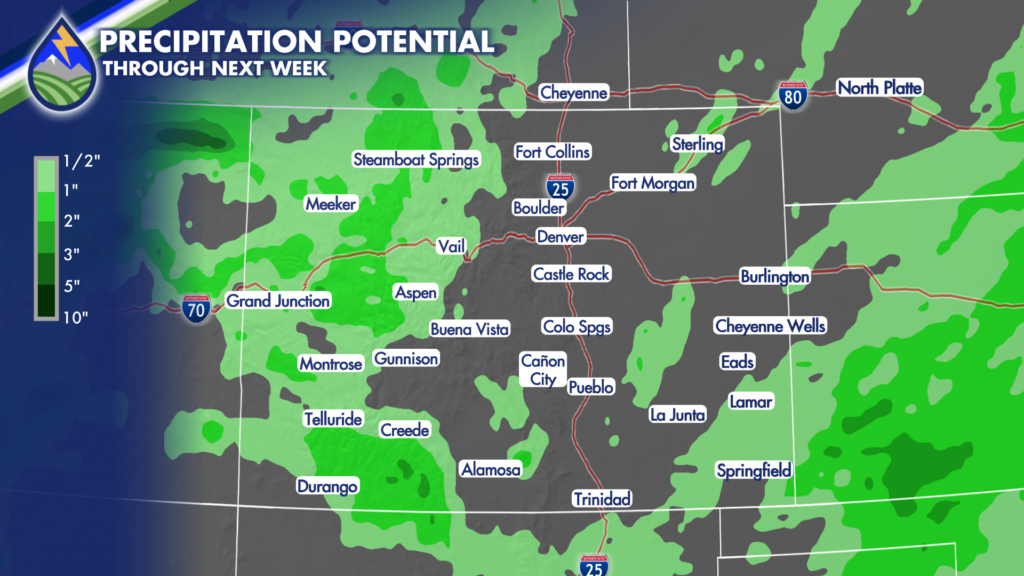
This setup has some similarities to last week’s tropical moisture event, but the current signal favors the western half of Colorado more than the I-25 corridor. Areas west of the Continental Divide, including the western slope and higher terrain, have the higher-confidence opportunity for increasing moisture beginning Sunday night and continuing through the first half of next week.
For southern Colorado, isolated showers and thunderstorms remain possible over the higher terrain Friday, with coverage increasing over the mountains as the weekend progresses. The San Luis Valley will also have a chilly start Friday morning, where a Frost Advisory is in effect from 2 AM to 9 AM. If you have sensitive plants in the valley, take the usual cold-weather precautions before bed Thursday night.
Saturday still looks warm on the plains, with highs in the 80s to near 90 degrees possible. High valleys will be cooler, generally in the 60s to around 70, as clouds and precipitation increase over the mountains. The southwest mountains and Continental Divide will be among the places to watch first as deeper moisture works into western Colorado.
Sunday and Monday may bring a more active stretch across the higher terrain, especially along the Continental Divide and southern mountains. Rain chances are expected to continue there as Pacific energy and tropical moisture interact. Travelers heading over mountain passes, campers, and anyone with outdoor plans in the high country should stay weather-aware for periods of rain and thunderstorms.
By Tuesday and Wednesday, the broader trough is expected to move farther inland and across Colorado. That is when the pattern could become more widespread, bringing cooler conditions and additional precipitation chances to more of the state. Mountain snow is also possible at higher elevations as snow levels lower, though exact locations and amounts will depend on how the system evolves.
Graphic below shows both the American (GFS) Model and the European Model bringing some congruence in rainfall rates mainly west of the Continental Divide next week
The eastern plains and I-25 corridor may eventually see some influence from Tropical Storm Simon’s remnants, especially during the middle of next week. But that part of the forecast carries lower confidence right now. Simon is still several days away, and small changes in its track, timing, and interaction with the larger trough could make a big difference in where rain sets up.
For Pueblo, temperatures are expected to trend downward around the middle of next week as the trough pivots through the region. Rain chances increase somewhat, but they are not especially high at this point because confidence remains limited for the eastern side of the state. The more certain change is a move away from the above-average warmth and toward cooler weather.
Woodland Park starts the weekend in the 70s, then temperatures could slide into the 40s and 50s by the middle of next week as the trough crosses the Continental Divide. That is a notable change from the warm start to the weekend and a good reminder to keep an eye on both daily temperatures and changing mountain weather if you have travel or outdoor plans.
Colorado Springs is forecast to reach about 83 degrees Friday, running above average for this time of year. Next week looks closer to seasonal, with cooler temperatures and at least some opportunity for rain. The exact extent of tropical moisture reaching the Front Range remains uncertain, so it is too early to focus on specific rain totals or narrow timing for the city.






