







A changing weather pattern is on the way for Southern Colorado, with warm conditions holding on for a few more days before cooler air and better precipitation chances arrive by the middle of next week. The biggest takeaway right now is the trend: temperatures turn noticeably cooler starting Tuesday, mountain precipitation becomes more likely, and the details become much less certain later next week.
First, a quick look beyond Colorado. Hurricane Isaias made landfall Friday evening near Fort Walton Beach in the western Florida Panhandle as a Category 2 hurricane. It is now post-tropical and moving quickly through parts of the eastern United States, but it has left destructive weather behind, including reports of tornadoes. This system is not affecting Colorado directly, though anyone traveling east by air over the next 24 hours could run into delays tied to the active weather across the East Coast. There is also plenty to watch in the eastern Pacific.
Hurricane Simon is expected to make landfall along Mexico’s west coast Sunday as a major hurricane. It will weaken after landfall, but some of its tropical moisture could eventually be picked up by the upper-level flow and make its way into parts of the central and eastern United States next week. That is one piece of a complicated pattern we will continue to watch closely.
Closer to home, the more immediate moisture source is tied to what remains of Tropical Storm Rachel. That moisture is being drawn northeastward toward Southern California, Nevada, the Great Basin, Utah, and the western slope of Colorado as a trough of low pressure pushes into the western half of the country. The result will be increasing clouds and precipitation chances over the higher terrain and western Colorado, while the eastern plains stay warmer and generally drier for the next several days. For Southern Colorado, the weekend stays warm, especially across the I-25 corridor and the eastern plains. High temperatures out east will continue running well above normal, with many communities reaching the 80s and some near 90 degrees. Higher valleys will be cooler, but still mild for October. The better rain chances will remain focused near the Continental Divide, especially across the San Juan Mountains, where tropical moisture in the southwest flow can support periods of rain. Sunday looks similar, with warm and dry conditions for Pueblo, Colorado Springs, Canon City, La Junta, Trinidad, and much of the eastern plains. Clouds and showers will be more common over the mountains, particularly along the Continental Divide and into the San Juans. A few thunderstorms cannot be ruled out in the higher terrain, and any heavier shower could bring localized downpours. Snow levels remain high through the early part of this pattern, so the first rounds of mountain precipitation will mostly fall as rain. Monday appears to be another transition day. The plains should remain warm and mostly dry, while moisture continues to increase over the mountains. This is a good time to enjoy the warmer stretch if you have outdoor plans across Southern Colorado, but keep an eye on the sky if you will be hiking, camping, or traveling through the higher passes. Conditions will become more unsettled as the larger western trough approaches.
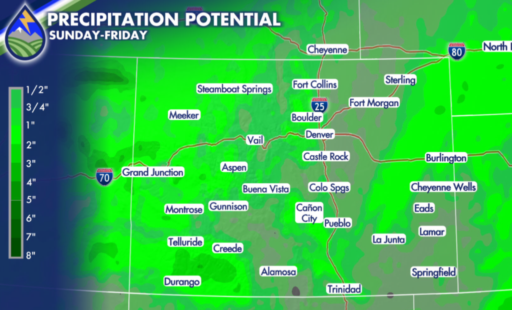
The more noticeable change arrives Tuesday. A cold front is expected to move through the region, bringing cooler temperatures to Southern Colorado by Tuesday and an even more fall-like feel by Wednesday. The eastern plains may drop from the 80s and near-90 readings into the 60s behind the front, while the mountains see increasing precipitation. As colder air arrives, rain is expected to transition to snow in the higher elevations late Tuesday into Wednesday. Mountain travelers should be prepared for changing conditions during that Tuesday and Wednesday window. Snow showers are possible over the higher terrain, and a few inches of accumulation could create slick spots and travel concerns over the passes. At this point, the forecast does not point to a specific high-impact snow event for Southern Colorado, but mountain weather can change quickly when colder air arrives with Pacific and tropical moisture in place.
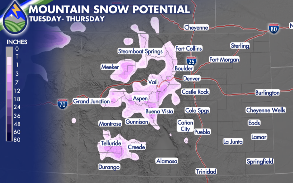
By Wednesday, Thursday, and Friday, Southern Colorado looks cooler overall, with ongoing chances for precipitation. Rain shower chances may spread farther onto the plains during the latter half of the week, while snow chances remain highest in the mountains. The exact placement, duration, and intensity of the precipitation are still far from certain, especially after Wednesday. That uncertainty is tied to the projected upper-level low, which could either move along more quickly or linger and even drift back west toward the Great Basin. That difference matters for the late-week forecast. A faster-moving system could bring a shorter stretch of cool, unsettled weather.






