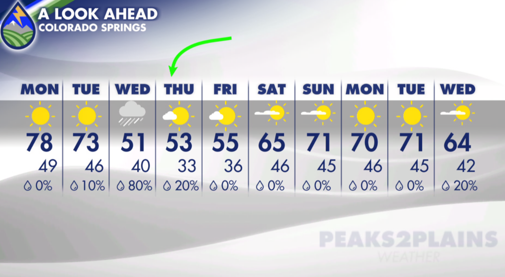
Monday will be our last notably warm day before a much cooler pattern settles in. Highs are expected to reach the upper 70s around El Paso County, with middle 80s across parts of the eastern plains. Gusty southwest winds around 25 to 30 mph will be persistent across much of Southern Colorado, helping keep lower elevations warm through downsloping. If you have outdoor plans, Monday looks like a good day for them across the I-25 corridor and plains, though it will be breezy. The mountains will carry the better chance for showers and thunderstorms Monday, especially around the San Juans and areas west of the Continental Divide. A few storms may pop up over the higher peaks, but widespread severe weather is not expected in Southern Colorado. Farther northwest, near and west of Steamboat Springs, a few stronger storms could produce hail Monday evening. The broader weather pattern is changing. A trough of low pressure moving in from the Great Basin is bringing Pacific moisture toward the western United States. That southwest flow will continue feeding moisture into Colorado’s western slope for the next several days. Freezing levels should remain too high for much snow through the next 48 hours, but that begins to change by Tuesday as colder air works closer. There is also something to watch farther south and west: Hurricane Simon, a major Category 4 hurricane off Mexico’s western coast. Simon is expected to weaken considerably as it tracks across the Mexican Plateau, but it could eventually get picked up by the upper-level pattern later this week. That may bring some tropical moisture into eastern Colorado and possibly Southern Colorado. It is still too early to say how much, if any, of that moisture reaches us, so this remains a detail to watch rather than a forecast certainty.Tuesday looks like a transition day. Temperatures will come down some, but the more noticeable cooldown arrives Wednesday. A cold front may push through the eastern plains Tuesday afternoon, so any highs near 80 degrees across the plains would likely happen early in the day. Behind that front, cooler air and increasing shower chances will move in. Wednesday is shaping up to be the day that feels dramatically different. High temperatures may only reach the 40s and low 50s in some locations, with passing showers possible. Woodland Park could struggle to get out of the 40s Wednesday and Thursday. The cooler pattern may linger into Thursday and Friday, with many areas hovering in the 50s before a gradual warmup heading into the weekend.
The higher terrain will be the first place to turn cold enough for snow showers as this system arrives. Mountain showers will continue for a few days, with snow becoming more likely by Wednesday as colder air deepens. High valleys west of I-25 may see their first freeze of the season Wednesday night into Thursday morning. Lower terrain areas could also get close to freezing, or briefly touch the freezing mark, late Thursday night into Friday morning.
It is important to keep that potential freeze in perspective. This does not currently look like a prolonged stretch of hard-freeze conditions. If you have not blown out your sprinklers yet, there is no need to panic over one brief brush with freezing temperatures. It takes several consecutive days of hard freezing weather for the ground to cool substantially. Still, it is a good time to keep an eye on the forecast, especially if you have sensitive plants or exposed plumbing.