High pressure is keeping Southern Colorado fairly quiet for your Monday, though the day begins with areas of fog and low clouds across the plains. That fog should gradually mix out through the morning and into the afternoon.
We’ll still have partly to mostly cloudy skies for many areas, but it will be dry, with temperatures a few degrees warmer than Sunday. Expect highs near 56 in Colorado Springs, around 50 in Pueblo, 48 in Ordway, 55 in Springfield, and near 62 in Denver. Overnight lows drop back into the 30s for many locations along and east of I-25, while Cañon City and Walsenburg stay a little milder, near 41 degrees.
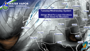
Tuesday starts out relatively quiet, but our next weather system will be moving closer from the Great Basin. Moisture will increase over the mountains during the day, with a few showers possible in the high country as early as Tuesday morning. The more active period arrives later Tuesday afternoon, Tuesday evening, and Tuesday night.
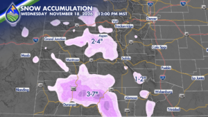
This is primarily a mountain-focused system. The San Juan Mountains are expected to see the best chance for accumulating snow, with several inches possible on the higher peaks. Around Summit County, mountain snow totals could reach 2 to 4 inches, while the Sangre de Cristo Mountains may pick up around 1 to 2 inches. The highest peaks of the San Juans could see roughly 3 to 7 inches of snow. Snow will begin at the higher elevations, including the San Juans, and continue Tuesday evening into the overnight hours as temperatures fall.
A few showers may spread into portions of the central mountains, around ski resort locations, and toward the Wet and Sangre de Cristo Mountains. Some mountain valleys and lower-elevation mountain communities could initially see rain before a change to snow.
If your travel plans take you into the high country early Wednesday, especially across the southwestern corner of Colorado, plan for winter driving conditions. Falling snow combined with strong winds could create slick roads and reduced visibility at times. This is a quick-moving system, though, and most of the mountain precipitation should be ending by Wednesday morning.
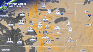
For communities east of I-25 and across the plains, this system is not expected to bring meaningful precipitation. Wind will be the main impact instead. Gusts could reach up to 55 mph in the high country from Tuesday afternoon through Tuesday night and early Wednesday. Lower elevations could see gusts up to 45 mph during that same stretch. The strongest winds are expected Tuesday night into Wednesday morning. Models show gusts near 40 mph around Pueblo by lunchtime Wednesday, with gusts near 37 mph possible around Cañon City. Winds should begin to ease Wednesday afternoon as the system moves away, but it will be a noticeably windy end to Tuesday and start to Wednesday for areas that miss out on precipitation.
Tuesday will be mild and breezy ahead of the system. Colorado Springs is expected to reach about 62 degrees, while Pueblo and much of the lower Arkansas River Valley should make it into the 60s. Springfield is forecast near 57, and Aspen near 54. The wind will be helping boost those temperatures during the day. Cooler air moves in Tuesday night and Wednesday, though temperatures across the plains still look fairly mild for this time of year. Colorado Springs is expected to top out near 56 Wednesday, with low to mid 60s possible farther east across the plains. The cooler conditions will be more noticeable in the high country, where snow remains the primary weather concern.
By Wednesday afternoon, conditions should be quieter as this fast-moving system exits. This is also the first of two systems on the way this week.
Another system is expected to move in Thursday into Friday, bringing another opportunity for mountain snow and wind. Stay with us for updates as the week’s weather pattern continues to take shape.
Get the Peaks2Plains Weather app for your local forecast, radar, and updates, and watch our 24-hour weather channel for Southern Colorado conditions whenever you need them.
Our Weather. Together.