


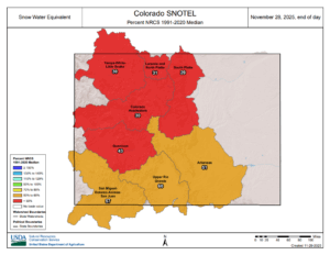
It’s been a very slow start to the snow season across southern Colorado and all of the Centennial State. As of the morning of the last day of the month, liquid water equivalent snow pack is running 41% of average in terms of snow water equivalent according to the Colorado Snotel program at the Natural Resources Conservation Service. In just the last two weeks, the numbers have come up a significant amount as November began with SWE snow pack was at 20% of average.
The slow start can be attributed partly to the weak La Nina in place along the equator in the Pacific Ocean off the west coast of South America. This tends to influence the mean position of the jet stream over the western United States during the fall, with a ridge in the western U.S. then diving south to the east of Colorado. The northern storm track tends to produce warm and dry stretches over the mountains.
In 2025, October precipitation in Colorado Springs was less than half of average as were other weather reporting stations along the Front Range. An abnormal and truly historic multi-day rain event that produced flooding in Pagosa Springs and Vallecito skewed numbers statewide. Even here though, October rain instead of snow helped lead to the slow start to the winter season in the high country.


