


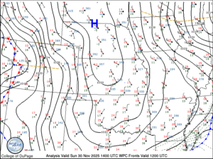
There is a large and cold airmass over the central plains of the United States on the final day of November. A plot of surface Theta-e values over the U.S. and surface wind barbs really help show the extent of the current arctic airmass over the country.
Theta-e, equivalent potential temperature, accounts for the initial temperature and moisture content of the air. We often use this to analyze the potential for severe weather and instability during thunderstorm season. It’s also useful when analyzing fronts as I’m doing here. There are so many different parameters that we measure or calculate in the atmosphere. One of my jobs as a public weather communicator is to pick the parameter that visually helps tell the story of what I’m trying to get across. I try to pick imagery that helps your eyes go where I want them to go, or notice contrasts that I want you to notice as I build the weather story.
A quick post on this because it’s a really good example! I’ve included the surface station plots at the same time so you can see how cold it actually is. The small red number next to each circle is the air temperature at the given weather station. The green is dewpoint temperature. Blue is pressure. The line coming off of the circle is a wind barb. It’s pointing into the direction the wind is coming from and the ticks off of the line represent the speed of the wind.


