HISTORICAL PERSPECTIVE
The remnants of Hurricane Polo added up to an impressive soaking across southeastern Colorado this week. CoCoRaHS volunteer rain gauges measured widespread totals of 3–5 inches across parts of the southeastern plains, with some locations in southern Prowers County approaching 7 inches. Farther north and west, amounts dropped off considerably toward Colorado Springs and the Interstate 70 corridor. Our map brings those reports together to show the overall pattern, with the shading estimating rainfall between gauges.
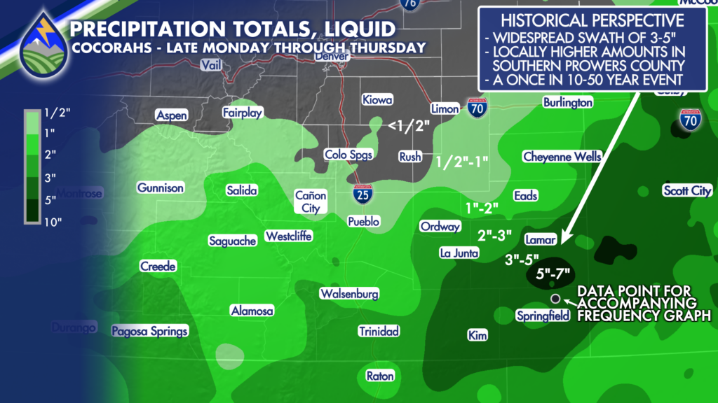
To put those totals into perspective, we used NOAA Atlas 14*, a reference that uses historical precipitation records to estimate how common—or uncommon—different rainfall amounts are at a particular location. It also considers how quickly the rain falls. Four inches in two days is a different event than four inches spread over a week. The accompanying graph uses Two Buttes as a reference for the heavier rainfall across far southeastern Colorado.
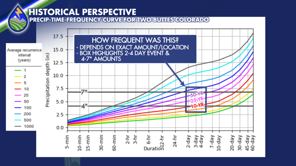
Around Two Buttes, roughly 4 inches in two days is near the estimated 10-year rainfall amount. About 5–5½ inches over two to four days is near the 25-year level, while roughly 6–6½ inches approaches the 50-year level. Totals near 7 inches fall between the 50- and 100-year estimates for those durations. That makes the 10–50-year range a useful description for many of the heavier totals, with some higher amounts even less common. The comparison depends on exactly where the rain fell, how much accumulated, and over how many days.
Those labels don’t mean we have to wait another 10 or 50 years for a repeat. A 10-year rainfall has roughly a 10% chance of being reached or exceeded in any given year at a particular location; for a 50-year rainfall, that chance is about 2%. Similar events can happen in back-to-back years. For this storm, the takeaway is that parts of southeastern Colorado received an unusually large amount of rain over several days, especially around southern Prowers County, while other communities saw a much more modest soaking.
*Special thanks to NWS Pueblo Hydrologist Justin Louen who got me to the right part of the Atlas 14 website to get this information.