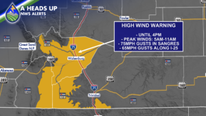
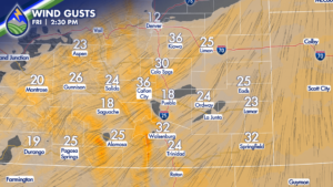
Wind is the big story across Southern Colorado this Friday with widespread gusts generally running from 20 to 40 mph. The strongest winds will be focused over the mountains, especially the southern Sangre de Cristo Mountains and parts of Huerfano County, where a High Wind Warning remains in effect until 4 p.m.

The most powerful gusts are expected from the early morning through late morning. Gusts up to 75 mph are possible across the Sangre de Cristo Mountains, while gusts near 65 mph are possible along portions of the I-25 corridor. These are the kinds of winds that can make driving difficult, especially for high-profile vehicles, trailers, and anyone traveling through exposed mountain passes or along wind-prone stretches of highway.

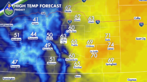
Across the lower elevations, it will feel warmer than the calendar may suggest, with downsloping winds helping temperatures climb into the 60s and 70s across the plains. Colorado Springs is expected to reach around 60 degrees Friday afternoon. That may sound pleasant, but the wind will be hard to ignore. Secure lightweight outdoor items, use extra caution around construction zones or loose debris, and keep both hands on the wheel if you are headed out on the road.

Mountain snow will accompany the wind, particularly across the high country. Snow begins spreading over the mountains during the first half of Friday, followed by a bit of a lull during the afternoon. Snow is expected to pick back up overnight as the next part of the system moves through.

If Friday travel takes you into the mountains, be ready for windblown snow and changing visibility during the first half of the day. Winter driving conditions may also develop again Friday night and into early Saturday morning. The snow itself will not be especially heavy in most places, but wind can make even lighter snowfall more difficult to travel through.

The San Juan Mountains look to pick up a general 1 to 4 inches of snow, with a few of the highest peaks potentially seeing 2 to 5 inches. Wolf Creek Pass could be among the locations with the higher totals. Central mountain areas may see around 1 to 3 inches, while the Sangre de Cristo Mountains are generally expected to see less than an inch. With strong wind in the mix, measured totals may be tricky, and drifting snow will be part of the travel concern.

Winds should begin to improve during the evening and overnight hours Friday. It will not become completely calm everywhere, with a few breezy pockets possible around Fremont County and across the southeastern corner of the state, but it should be a significant improvement compared with the daytime wind. As winds ease, temperatures will be able to fall more efficiently, dropping into the 30s by early Saturday in many lower-elevation locations.

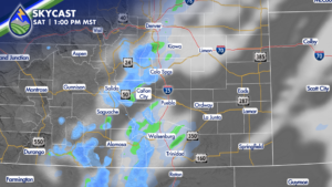
A cold front moves through late Friday night into early Saturday morning. It will briefly turn winds around and create a little upslope flow, opening a window for a few showers and snow showers Saturday. Early Saturday, a few showers may reach the Denver metro area. If you are heading north to Denver International Airport to pick up or drop off Thanksgiving visitors, allow a little extra time and be prepared for a few showers around the morning hours.

As the front shifts farther south, the shower chance shifts south with it. By late morning into early afternoon Saturday, a few showers may reach the Pikes Peak region, the Palmer Divide, and eventually parts of the plains later in the afternoon and evening. Moisture with this system is limited, so this is not expected to be a high-impact event for the I-25 corridor or the eastern plains.

Around Teller County, minor accumulations are possible, generally less than an inch and mostly on colder surfaces such as grass, windshields, decks, and elevated surfaces. Around Colorado Springs, the lower Pikes Peak region, and the Palmer Divide, a dusting is possible at best. Roads are likely to remain too warm for much accumulation, though drivers should still watch for brief reductions in visibility or a slick spot if a shower passes at the right time.

For anyone hoping to see a few flakes, Saturday brings at least that chance. It may look and feel more like November for a little while, but widespread travel problems or meaningful snow totals east of the mountains are not expected. The bigger weather story remains Friday’s wind, followed by a cooler transition into the weekend.

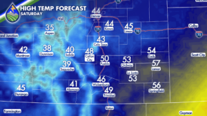
Saturday temperatures will depend on how quickly the cold front arrives. Locations that see the front earlier will stay cooler. Colorado Springs is expected to top out near 44 degrees, while southeastern Colorado locations that hold onto warmer air longer, including Springfield, could reach the middle 50s before the cooler air arrives.

By Saturday evening, the system moves east and conditions begin to settle down.

Our Weather. Together.