A storm is set to move across Colorado over the next 36 hours, bringing a nice widespread snow to the area. The Wednesday morning commute is likely to have winter travel impacts over a good portion of the region from the mountains into the cities along the Front Range.
The Set Up
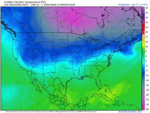
The upper level wave ends up along the Utah/Colorado border early Wednesday, bringing west-southwest flow between 13,000-18,000′ over the top of some colder air sliding down the Front Range. This is a classic pattern that produces “over-running” or isentropic upglide on the more formal side of things. This is a nice general ramp of lift on the large scale that will combine with typical terrain effects to produce some localized areas of enhancement. There will be some enhancement on the west and southwest facing slopes over the ski resorts ahead of the heart of the upper-level system, but even better terrain enhancement will occur along the eastern slopes of the Rockies.
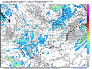
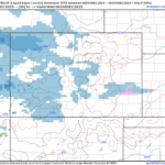
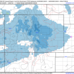
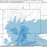
In these spots west of Denver, the Rampart Range, the Wet Mountains and the Sangre de Cristo range, there is low-level upslope that coincides with this mid and upper-level lift I describe above. The combination of these two mechanisms of lift is best captured in the 700mb vertical velocity plot at 5 am on Wednesday. The blues show where lift is expected to occur at about 12,000′ and the green color show where this is maximized. At the same time you see another area of lift over northern Arizona near the heart of the storm’s circulation.
Snow Timing
Snow will spread over the mountains and ski-resorts through the day Tuesday and begin to impact the eastern mountains west of Interstate 25 toward sunset. Snow will spread east along the cities in earnest early Wednesday morning and shift south gradually through the day, ending from north to south in the mid-afternoon through the evening.
Snow Amounts
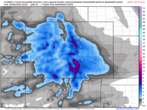
This should be a nice little storm overall. As mentioned above, the highest amounts will be on the terrain of the eastern mountains west of Interstate 25 and over the Palmer Divide’s northern slopes across Douglas and Elbert counties. Over the Sangre de Cristo peaks some spots may near a foot of snow way up high. Most areas where homes and cabins are to be found will be between 5 and 9″ as it appears now, with snow on the order of 2-6″ expected from Colorado City south to Trinidad on I-25. Colorado Springs and Pueblo proper are likely to get a couple of inches and perhaps up to as much as 4″ while the surrounding higher terrain should get 3-6″, including Monument and most of Teller County.